
By Giana Magnoli, Noozhawk News Editor | @magnoli | Published on 02.28.2015 12:26 p.m.
Lawsuit settlement requires six separate City Council districts, two of which must have a majority of Latino eligible voters
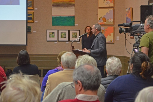 Now that the City of Santa Barbara has settled a lawsuit and agreed to start using district elections beginning in November, the City Council wants input on what those six districts should look like.
Plaintiffs alleged Santa Barbara’s at-large voting system diluted Latino votes and made it difficult for those voters to elect their preferred candidates, City Attorney Ariel Calonne explained at a public engagement meeting on the subject Saturday.
The court case was to go to trial in April but the settlement was finalized last week, making the meeting focus on district boundaries. The city must pay $599,500 in legal fees to the plaintiffs’ attorney, Barry Cappello, but avoiding a multimillion-dollar court payout was one of the reasons for settling, Calonne said.
City Council members and the mayor are elected on an at-large basis now, so candidates can live anywhere and voters can choose any candidates they want.
With six districts — as agreed-upon in the court settlement — at least two must have a majority (over 50 percent) of Latino eligible voters, meaning citizens over the age of 18. In draft maps, those two districts are centered around the Eastside and Westside neighborhoods.
The mayor will still be elected at-large, by all city voters.
For the November 2015 election, three of the new six districts will be implemented for the three open City Council seats. Since Councilman Randy Rowse will be up for re-election, it’s likely the district in which he lives — on the Mesa — will be on the ballot along with the two Latino-majority districts, Calonne said.
The rest of the city won’t be voting in November.
Several people at Saturday’s meeting advocated for changing to even-year city elections as a way of improving voter turnout, including Latino voter turnout, but Calonne said that can only be changed by a vote of the people.
Members of the public are invited to help design district maps and a consultant from National Demographics Corp. explained the complicated online mapping program people can use to draw their own maps of the city. It’s similar to ArcGIS with U.S. Census data, detailed local maps and satellite imaging built in.
The goal is to have six districts with equal populations, of around 14,735 residents each, that keeps neighborhoods and other communities of interest together. All the official neighborhoods from the city’s General Plan are labeled and outlined in the maps.
For people drawing maps at home, the districts should be “reasonably shaped,” contiguous and keep neighborhoods together when possible, said Doug Johnson, president of National Demographics Corp. There are three draft maps that can be used as starting points, or people can start from scratch.
The plaintiffs who filed the lawsuit will be submitting their own district maps for consideration, Cappello said at the meeting. He said he has concerns with one of the draft maps, saying the Westside neighborhood is “diluted” by adding the Pilgrim Terrace Park area, which is largely non-Latino, and the area near Leadbetter Beach that is populated with many Santa Barbara City College students and is traditionally part of the Mesa neighborhood.
That map “violated the spirit of the agreement,” Cappello asserted.
District boundary lines must be submitted to the court by early April and then to the Santa Barbara County Registrar of Voters by June or July so that office can draw out precincts before the November election.
Public input on maps will only be accepted until March 12.
The mapping tools are English-only but National Demographics Corp. has Spanish-speaking staff members who can work directly with groups, Johnson said. His tutorial during Saturday’s meeting was also interpreted for the video made by City TV.
Submit maps through the online tool, or people can draw them out with pens and paper and submit them to the City Clerk’s Office at 735 Anacapa St. Maps also can be scanned and emailed to gpeirce@santabarbaraca.gov or faxed to 805.897.2623.
Another public meeting and mapping tutorial is scheduled for 6 p.m. March 18 in the Council Chambers at City Hall.
The City Council ultimately will decide which district maps to use and is holding meetings at 2 p.m. March 24 and 4 p.m. March 30, both at City Hall.
Johnson provided some tips on using the mapping program and his tutorial will be posted online on Monday, the city said. Once users create an online account, they can read how to use the program in the “learn” tab at the top and then draw maps through the “create” tab and ultimately share or submit them to the city.
Johnson emphasized that the city wants to know the reasoning behind mapping choices so it helps City Council members make their decision.
— Noozhawk news editor Giana Magnoli can be reached at gmagnoli@noozhawk.com. Follow Noozhawk on Twitter: @noozhawk, @NoozhawkNews and @NoozhawkBiz.

